12.27.2009

Lonestar Geyser (Winter):

Another quick post. This was my hike today, out and back to Lonestar Geyser along with a stop at the Kepler Cascades. This geyser is known as Lonestar because it is located roughly 3 miles from any other major geyser, the closest being old faithful. It is one of the few geysers to be so isolated, most exist among a much larger network of springs, pools, and geyser (known collectivly as a basin). This was a great hike, waited about two hours to witness the eruption, it is always very fascinating to watch geysers build to eruption. Also, met a very nice pair of guests who seemed equally ensconsed in watching the geyser build to eruption. One thought worth keeping in mind when looking at these pictures, the geyser cone for Lonestar is about six feet high. Cones generally grow at about 1-2 inches in a hundred years.

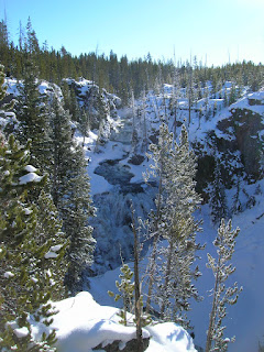
Kepler Cascades are simply a small set of falls along the Kepler river, far more interesting in the winter than in summer. As usual, enjoy. The first pic is up river from the falls, the next two are the falls themselves.




Lonestar Geyser Cone (early stages of eruption):


Full eruption at various stages (going backwards from the end):

Steam phase near the end, took this as I was leaving the geyser, might be my favorite picture:


Steam/Water phase (about halfway through) up close:


Full water phase (about 5 minutes after it started):


Steam from geyser liquid run off, this was a couple hundred yards from the geyser, but as erupted the water grew warmer and warmer, producing more and more steam:


These last few are just dumb luck great timing shots of Old Faithful village (ie home) as old faithful erupted shrouding the entire area in steam/fog:

The tall plume is a geyser, the rest is just settling in all around the area:


This is literally 2 minutes later, you can see the growth. Tiny spot dead center just below the horizon is the OF Inn, this shot was incredible dumb luck. If I had stared any longer and not gotten my camera out I may have missed it.:

Biscuit Basin/Mystic Falls Winter

Here is the beginning of my (documented) winter adventures. Snowshoed out Biscuit Basin from Old Faithful. This was a hike I had done more than once this summer however, the snow brings a new dimension to the beauty of this place. It is also worth noting that these last two days have been the sunniest since I have been in the park. Not a whole lot else to say about this one, enjoy the pics.

Cliffs near the Falls:


The basin from an overlook:


Riverside Geyser (first time catching this):


Random tree:


Castle Geyser:


Old Faithful:


Mystic Falls (created by the Little Firehole River falling off the Madison Plateau into the Firehole valley):


Just a cool shot of the woods:


12.13.2009

Grand Tetons - Ampatheater Lake

Long time no update, this was due to a very hectic end of last season, then a following two months of little internet. That aside it is time to update these pictures. For those not aware, I have returned to Yellowstone for the winter. The arrival of a camera and a good pair of cross country skis should mean even more pictures. This place is even more stunning with snow, the flight over Wyoming from Denver was like looking at something out of a dream The snow showed every wind pattern, river course, and rock slide in beautiful relief. All that aside here is my one hike completed in the Tetons, Ampatheater Lake. This was a long haul up a 9,800ft lake, and then for me a short jaunt to a saddle affording me a view of Jackson Hole (the geographic feature not the town), and down into Glacier Canyon. Absolutely stunning hike, and experience a Moose up close and personal was pretty great too. It is also worth noting that at some point I'm going to upload every single Yellowstone Hike picture (good and bad) to a online photo album, once I get to this I will share the link.

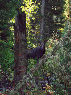
A moose:


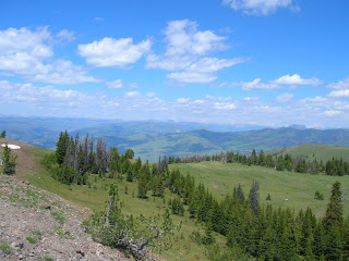
Views into Jackson Hole


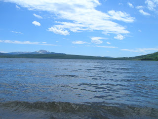
Surprise Lake (which lies right below Ampatheater):

Amphitheater Lake and Glacial Canyon from top of saddle:


Shore of Ampitheater Lake:

8.05.2009

Whitewater Rafting

This rafting trip will lead to me spending too much time and money on watersports. This was an event organized by our rec department through a private company. The trip involved travelling down the Gallatin River through rapids all the way up to a Class IV. The thrill of riding through large rapids was enjoyed along with staring at beautiful scenery that was around us. This included mountains and various waterfowl. All of which helped us ignore the fact that we were pushing the limits of hypothermia. All these pictures were taken by the company and we bought a disc as a group. The people in the boat are myself and Brian in the front, Dan and Anna in the next road, and Glenn and Alex (the guide) in the back. (Pictures are very large, beware if you click on them)


Speciman Ridge

Long time since the last post, mostly due to poor Internet. This was one of the crazier hikes I have done since being here. It was long (23 miles), a hard to find trail (lost it numerous times) and involved fording the Lamar River. However, it was probably one of my favorite hikes since arriving here. There was prolific wildlife, including Pronghorns (fastest land animal in N. America), buffalo, and a coyote. This hike took place in the Lamar Valley in the Northeastern corner of the park. This is one of the lowest and warmest areas of the park and shows very well the extreme diversity of landscapes here in the park. I would have taken more pictures but became much to exhausted.

View from Amethyst Mtn (9,200ft):


Elk Skull (many die throughout the winters):
Bison and Pronghorn with Mt. Washburn in the back:

Cass, Anna, Matt fording the Lamar (taken while I was still standing in the river enjoying the cool water):


7.13.2009

Heart Lake

Another great backcountry lake not far from Grant. This lake is the fourth largest in the park and sits at the base of Mt. Sheridan (the highest peak in the red mountains). There is not a lot to say about this hike. It was mostly just lots of woods hiking and brief stint through a large open valley leading down to the lake. There were also a few small thermal areas along the trail, which always adds an interesting element to a hike. Being able to lie on a remote beach and watch a pelican fish was certainly the highlight of this trip. This trip also marked my completion of the employee 100 Mile Hiking Club. I hope to return to this hike and climb Sheridan, however its a 21 mile hike with 5,000+ft of elevation change (over the course of 5 miles) if Sheridan is added.

Valley Leading down to Heart Lake:


View of the lake from the shore:


Mt. Sheridan:

Seven Mile Hole

This is easily the hardest hike I have ever been on, one section drops roughly 1300ft into the floor of the Grand Canyon of Yellowstone. The first three miles of the hike skirt the rim of the canyon, and offers some spectacular views. Including a view of Silver Cord Cascade, which drops off into the canyon over 1200ft. Overall it was an extremely challenging yet equally rewarding hike.

Silver Cord Cascade:

Canyon Floor/Yellowstone River:


7.01.2009

Avalanche and Hoyt Peaks

I'm skipping a large number of hikes to just post my hike from today, the rest really don't compare. These are two peaks of the Absaroka Mountains, each about 10,500ft at the summit. Easily the highest I have ever climbed. The hike up was not too bad, only 5 or 6 miles however, there was easily 8,000ft of elevation gained or lost over the course of the hike. The hike begins on Avalanche then continues on a saddle over to a rather technical climb up to the peak of Hoyt. There are not many pictures of my descent, mostly because I was too busy not falling off the mountain. Not much to note, what you see is basically Yellowstone Lake, Avalanche, Hoyt, and some small mountain lakes that exist due to snow melt. This is without question my favorite hike (replacing yesterday where I hiked off Bunsen Peak in 70mph winds). Enjoy

Snow melt lake:
Yellowstone Lake from Hoyt:
Avalanche from Hoyt:


Hoyt Peak:

Some snow melt lake from Hoyt Peak:
Yellowstone Lake from Avalanche:
Absarokas:
Avalanche from the base: